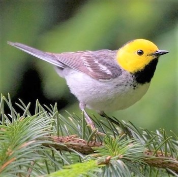

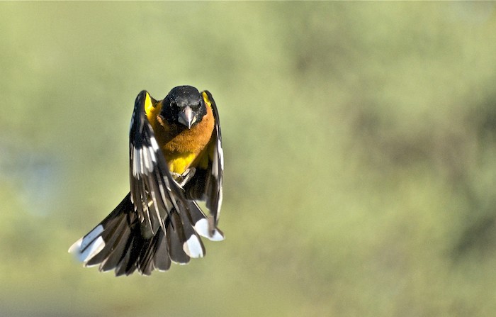

Amy carefully lifts the threads of the mist net over the bird’s white speckled wings (briefly exposing its yellow “wing pits”) slipping them over its striped head, and carefully avoiding its stout beak. The bird is freed from the net and Amy, a permitted bird bander, holds in her hand not just a Black-headed Grosbeak, but a big opportunity. In addition to the chance to collect valuable demographic data about the grosbeak, such as age and sex, advances in tracking technology and genetics give bird banders like Amy an opportunity to learn vital information about migratory bird species.
A new study published in the journal Ecology and Evolution, by IBP scientists and colleagues from Point Blue Conservation Science and the National Park Service, integrates MAPS demographic data, individual movement data collected using GPS tracking devices, and climate data to understand the population dynamics of widely-distributed, migratory species- the Black-headed Grosbeak. Because migratory species spend their lives in two (or more) places, conserving them requires understanding their population dynamics and environmental stressors in multiple locations across their annual migratory cycle.
The Monitoring Avian Productivity and Survivorship (MAPS) and the Monitoreo de Sobrvivencia Invernal (MoSI, a.k.a. “Monitoring Overwintering Survival”) bird monitoring programs are large, long-running networks of bird banding stations that follow standardized protocols to age birds as precisely as possible using molt, plumage and other characteristics. Age data collected by these programs allow scientists to estimate important population measurements like productivity (number of young produced), recruitment (how many breeding adults are added to the population) and survivorship (how long do individuals survive). The MAPS program operates in North America on the breeding grounds of Neotropical migrant birds and the MoSI program operates on their wintering grounds from Mexico to South America and the Caribbean.
To conserve migratory species, its important to understand “migratory connectivity”- how breeding and wintering populations relate to each other. In other words, where in the wintering range do specific breeding populations overwinter. In an ideal world, MoSI banders would recapture birds banded by MAPS banders thus connecting the dots between breeding populations and their wintering grounds. But in the real world, the odds of that are akin to winning a 40 million dollar lottery jackpot. But as both the size and cost of GPS and other tracking devices decreases, our ability to use them to track bird movements expands. In addition, advances in genetic analysis allow scientists to link breeding and wintering populations using DNA extracted from a single feather collected by bird banders, as in the very successful Bird Genoscape Project.
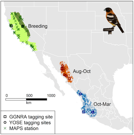
Figure 2 from Saracco et al., 2022. Distribution of Black-headed Grosbeaks that breed in two U. S. Bird Conservation Regions (Coastal California [light green] and the Sierra Nevada [darker green]) across the annual cycle. GPS-tagged birds were recaptured at sites in Yosemite National Park (YOSE; three birds, two MAPS stations) and Golden Gate National Recreation Area (GGNRA; one bird). Locations of these birds during the non-breeding season were separated into two distinct periods. Molting locations of individuals (more than oneif they moved within-season) are indicated by dark orange shapes (circles for Yosemite, squares for Marin) within an orange molting range defined as a shrub and forest habitat-filtered minimum convex polygon +0.5-degree buffer surrounding August through mid-October locations. Overwintering locations are indicated by blue shapes (per above, based on region, with only three birds with winter data) within a similarly defined blue region surrounding late October through March locations (Artwork by L. Helton.)
This Black-headed Grosbeak study examined two breeding populations of grosbeaks: those breeding along the coast and Central Valley of California and those breeding in the Sierra Nevada. The researchers used demographic data from 44 MAPS stations operated by IBP, Point Blue, the National Park Service, and independent operators, and was done with support from the March Conservation Fund and Yosemite Conservancy. Researchers fitted 33 adult Black-headed Grosbeaks with archival GPS tags, which do not transmit data- instead the data must be downloaded directly from the recovered device. Archival tags are smaller and lighter than tags that transmit, which is advantageous for use on songbirds; however, they require recapturing the bird to access the data about its movements. Four of the tagged grosbeaks were recaptured and in August all four moved from their breeding grounds in California to molting grounds in northwest Mexico where they remained until October when they moved to their wintering grounds hundreds of miles farther south in Mexico.
The researchers then developed a new statistical model to analyze the effects of climate variables, such as drought and timing of rainfall on Black-headed Grosbeak populations. They showed that the signal of climate variation was clearly evident in vegetation characteristics, such as the timing of green-up and amount of primary productivity across the annual cycle. Effects of climate on the bird populations were less clear. However, as expected, survival tended to be highest in years with relatively cool, wet winters. Recruitment of birds in the coastal California population was also positively associated with cool, wet winters and with relatively early rainfall on molting grounds. Lead author and IBP Research Ecologist Jim Saracco says that the basic approach taken in the study can be extended to many other bird populations and species:
“The neat thing about Black-headed Grosbeaks is that the adults can be readily aged as either ‘second-year’ or ‘after second year’ and so we have good ‘micro-aging’ data on these birds going back to the beginning of the MAPS program in 1990. These age data were an important part of our population model because they provided information on recruitment, essentially how many second-year birds there were relative to adults in the previous year, which is otherwise lacking in the model. Thanks to the work of Peter Pyle and many other dedicated banders over the years, we’ve gotten a lot better at this micro-aging of many other species of birds, so this type of model should be available for application to a growing suite of MAPS species in the future. Overall, I envision that the migratory connectivity data, the monitoring data, and the modeling methods will all continue to improve in the coming years, and MAPS cooperators will play a central role in facilitating these developments.”
Saracco and his co-authors emphasize that the MAPS program (and the MoSI program) are ideal platforms for investigating migratory connectivity using tracking, genetic or other technology:
“There is a growing list of these tools that we have at our disposal for making migratory connections, including not just archival tracking data like we used in our study, but morphometric data like wing cord measurements, as well as genetic and stable isotope data (among other things). Any of these data sources can be leveraged, individually or in combination, to help us better understand how birds move across the annual cycle. My primary interest is in how these migratory connections then relate to the demography and dynamics of populations, and for that MAPS provides a natural platform for studying both the movements and their potential consequences for populations across space and time.
One nice thing about tracking data compared to these various other data sources is that it provides fine-scale data on movements of individuals, which we can relate to climate or other environmental data to help us develop and test hypotheses about what factors might be influencing why and when birds move between sites or habitats. For instance, in this study tracking devices allowed us to define the populations’ molting grounds… Just as MAPS has been the source of many of the feather samples used to develop North Amrerican bird genoscapes, I think that it can play a similar role in the deployment and recovery of GPS tags like we used here, as well as for deploying other tracking devices that can help us to better understand movement, like the tags used in the automated radiotelemetry program, MOTUS.”
A bird in the hand, like Amy’s grosbeak, is an opportunity that we should make the most of. The MAPS and MoSI programs train and encourage banders to use molt, plumage and other criteria to determine age as accurately as possible. This rigorous data collection allows scientists to estimate population metrics that are critical for understanding and conserving bird populations. As techniques and technology for studying migratory connectivity advance we should all be looking for ways we can use them to get even more vital information out of the birds in our hands.